


The Pacific Palisades Fire continues to rage across Los Angeles County, fueled by powerful Santa Ana winds. The fast-moving blaze has scorched thousands of acres, destroyed structures, and forced tens of thousands of residents to evacuate. Here’s an in-depth look at the current situation, including evacuation details, fire maps, and resources.
Key Developments:
- Acres burned: Over 2,900 as of Tuesday evening
- Evacuations: Mandatory for more than 30,000 residents
- Destruction: Homes, schools, and other structures have been consumed
- State of Emergency: Governor Gavin Newsom has declared an emergency in Los Angeles and Ventura Counties
Where Is Pacific Palisades?
Pacific Palisades is a coastal neighborhood in Los Angeles, nestled between Santa Monica and Malibu. Known for its stunning ocean views and serene atmosphere, the area has become the epicenter of a wildfire that has rapidly grown out of control, threatening homes and businesses.


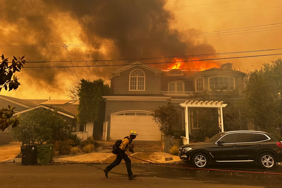
Fire in Pacific Palisades: What We Know So Far
The Pacific Palisades Fire began southeast of Palisades Drive on Tuesday morning. Within hours, it had expanded to over 2,900 acres, driven by gusting winds reaching up to 60 mph. Cal Fire has reported extreme fire behavior, including long-range spotting, making containment efforts especially challenging.
Palisades Fire Map and Evacuation Zones
The spread of the fire has led to widespread evacuations. Residents in affected areas are urged to leave immediately.


Key Evacuation Areas:
- From Calabasas to the Pacific Ocean
- From Malibu to San Vicente Boulevard
- Areas near Piedra Morada Drive and Pacific Coast Highway
Stay updated on evacuation zones and fire activity with the official Palisades Fire Map from Cal Fire:
View Palisades Fire Incident Map.
Shelter and Emergency Resources
Residents displaced by the Pacific Palisades evacuation can seek shelter at:
Westwood Recreation Center
1350 South Sepulveda Blvd., Los Angeles, CA 90025
This location provides food, shelter, and support for evacuees.
Santa Ana Winds: A Major Fire Threat
The Santa Ana winds, known for their strength and dryness, are a critical factor in the rapid spread of the fire. The National Weather Service has issued red flag warnings for Los Angeles and Ventura Counties, lasting until Thursday evening.


Wind Impact:
- Gusts up to 80 mph, with isolated peaks above 100 mph in mountain areas
- Dangerous conditions leading to power outages, road closures, and increased fire risks
Road Closures and Utility Disruptions
The fires and high winds have caused significant disruptions across the region:
- Topanga Canyon Boulevard is closed between Mulholland Drive and Pacific Coast Highway.
- Utility companies are considering power shutoffs for over 500,000 customers to reduce fire risks.
Preparing for Evacuation
If you’re in an area near the Pacific Palisades fire, take these precautions:
- Pack essential items, including medications, important documents, and emergency supplies.
- Monitor real-time updates through the Palisades Fire Map and local news.
- Follow evacuation orders immediately to ensure your safety.
Governor Newsom Declares State of Emergency
Governor Gavin Newsom has declared a state of emergency to mobilize resources for the firefight. The declaration allows additional state assistance and grants, ensuring fire crews have the tools they need to protect residents and structures.
The Impact of the Pacific Palisades Fire
As of Tuesday night, the fire in Pacific Palisades has devastated homes, displaced thousands, and placed significant strain on emergency responders. Governor Newsom’s declaration of a state of emergency highlights the gravity of the situation.
While firefighters work tirelessly to contain the blaze, residents are urged to remain vigilant and heed evacuation orders.
Stay Updated: For the latest information on the Palisades fire map, evacuation orders, and road closures, monitor Cal Fire’s website and local news channels.


